|
Annex4 |
Aeronautical Charts. |
|
Doc 8697 |
Aeronautical Chart Manual |
|
Doc 8168 |
Aircraft Operations, Vol. II
(Construction of visual and instrument flight procedures) |
| TITLE OF SERIES | SCALE | CHART NAME AND/OR NUMBER | PRICE PER SHEET RO. | DATE | |
|---|---|---|---|---|---|
|
Aerodrome Obstacle Chart-ICAO Type A
(AOC) |
1:20 000 |
DUQM/Duqm RWY 04/22 |
AD 2.OODQ -17 |
|
6 OCT 22 |
|
1:20 000 |
FAHUD/Fahud RWY 13/31 |
AD 2.OOFD - 15 |
|
21 APR 22 |
|
|
1:15 000 |
JA’ALUNI/Ja’aluni RWY
03/21 |
AD 2.OOJA - 13 |
|
29 MAY 14 |
|
|
1:20 000 |
MARMUL/Marmul RWY 14/32 |
AD 2.OOMX - 19 |
|
23 APR 20 |
|
|
1:20 000 |
MUKHAIZNA/Mukhaizna RWY
14/32 |
AD 2.OOMK -15 |
|
5 OCT 23 |
|
|
1:20 000 |
MUSCAT/Muscat Intl RWY
08L/26R |
AD 2.OOMS - 39 |
|
13 JUN 24 |
|
|
1:20 000 |
MUSCAT/Muscat Intl RWY
08R/26L |
AD 2.OOMS - 41 |
|
13 JUN 24 |
|
|
1:15 000 |
QARN ALAM/Qarn Alam RWY
12/30 |
AD 2.OOGB - 15 |
|
5 OCT 23 |
|
|
1:20 000 |
SALALAH/Salalah RWY 07/25 |
AD 2.OOSA -25 |
|
23 APR 20 |
|
|
1:20 000 |
SUHAR/Suhar RWY 15/33 |
AD 2.OOSH - 21 |
|
7 OCT 21 |
|
|
Aerodrome Obstacle Chart-ICAO Type B
(AOC) |
1:20 000 |
DUQM/Duqm |
AD 2.OODQ - 19 |
|
23 APR 20 |
|
1:20 000 |
FAHUD/Fahud |
AD 2.OOFD - 17 |
|
21 APR 22 |
|
|
1:20 000 |
JA’ALUNI/Ja’aluni |
AD 2.OOJA - 15 |
|
29 MAY 14 |
|
|
1:20 000 |
MARMUL/Marmul |
AD 2.OOMX - 21 |
|
23 APR 20 |
|
|
1:20 000 |
MUKHAIZNA/Mukhaizna |
AD 2.OOMK - 17 |
|
5 OCT 23 |
|
|
1:20 000 |
MUSCAT/Muscat Intl |
AD 2.OOMS - 43 |
|
13 JUN 24 |
|
|
1:20 000 |
QARN ALAM/Qarn Alam |
AD 2.OOGB - 17 |
|
5 OCT 23 |
|
|
1:20 000 |
SALALAH/Salalah |
AD 2.OOSA - 27 |
|
23 APR 20 |
|
|
1:20 000 |
SUHAR/Suhar |
AD 2.OOSH - 23 |
|
7 OCT 21 |
|
|
Precision Approach Terrain Chart-ICAO
(PATC) |
1:2 500 |
MUSCAT/Muscat Intl RWY
08L |
AD 2.OOMS - 45 |
|
5 OCT 23 |
|
1:2 500 |
MUSCAT/Muscat Intl RWY
26R |
AD 2.OOMS - 47 |
|
5 OCT 23 |
|
|
1:2 500 |
SALALAH/Salalah RWY 07 |
AD 2.OOSA - 29 |
|
9 NOV 17 |
|
|
1:2 500 |
SALALAH/Salalah RWY 25 |
AD 2.OOSA - 31 |
|
9 NOV 17 |
|
|
Terminal Area Chart-ICAO
(TAC) |
MUSCAT/Muscat Intl |
||||
|
1:750 000 |
TMA Chart Muscat |
AD 2.OOMS - 49 |
|
13 JUN 24 |
|
|
1:1 500 000 |
DEP/ARR Standard RNAV
Routes |
AD 2.OOMS - 51 |
|
>5 SEP 24 |
|
|
SALALAH/Salalah |
|||||
|
1:750 000 |
ATC Surveillance Minimum
Altitude Chart |
AD 2.OOSA - 33 |
|
25 APR 19 |
|
|
Standard Departure Chart
Instrument-ICAO (SID) |
DUQM/Duqm |
||||
|
1:750 000 |
RNAV (GNSS) RWY 04 |
AD 2.OODQ - 21 |
|
23 APR 20 |
|
|
1:750 000 |
RNAV (GNSS) RWY 22 |
AD 2.OODQ - 23 |
|
23 APR 20 |
|
|
FAHUD/Fahud |
|||||
|
1:500 000 |
RNAV (GNSS) RWY 13 |
AD 2 OOFD - 19 |
|
6 OCT 22 |
|
|
1:1 000 000 |
RNAV (GNSS) RWY 31 |
AD 2.OOFD - 21 |
|
6 OCT 22 |
|
|
MARMUL/Marmul |
|||||
|
1:500 000 |
RNAV (GNSS) RWY 14 |
AD 2.OOMX - 23 |
|
6 OCT 22 |
|
|
1:500 000 |
RNAV (GNSS) RWY 32 |
AD 2.OOMX - 25 |
|
6 OCT 22 |
|
|
MUKHAIZNA/Mukhaizna |
|||||
|
1:500 000 |
RNAV (GNSS) RWY 14 |
AD 2.OOMK - 19 |
|
5 OCT 23 |
|
|
1:500 000 |
RNAV (GNSS) RWY 32 |
AD 2.OOMK - 21 |
|
5 OCT 23 |
|
|
MUSCAT/Muscat Intl |
|||||
|
1:750 000 |
RNAV (GNSS) RWY 08L |
AD 2.OOMS -
53 |
|
13 JUN 24
|
|
|
1:750 000 |
RWY 08L |
AD 2.OOMS - 57 |
|
13 JUN 24 |
|
|
1:750 000 |
RNAV (GNSS) RWY 26R |
AD 2.OOMS -
59
|
|
13 JUN 24 |
|
|
1:750 000 |
RWY 26R |
AD 2.OOMS - 65 |
|
13 JUN 24 |
|
|
QARN ALAM/Qarn Alam |
|||||
|
1:600 000 |
RNAV (GNSS) RWY 12 |
AD 2.OOGB - 19 |
|
6 OCT 22 |
|
|
1:600 000 |
RNAV (GNSS) RWY 30 |
AD 2.OOGB - 21 |
|
6 OCT 22 |
|
|
SALALAH/Salalah |
|||||
|
1:500 000 |
RNAV (GNSS) RWY 07 |
AD 2.OOSA - 35 |
|
25 APR 19 |
|
|
1:500 000 |
RWY 07 |
AD 2.OOSA - 37 |
|
25 APR 19 |
|
|
1:500 000 |
RNAV (GNSS) RWY 25 |
AD 2.OOSA - 39 |
|
25 APR 19 |
|
|
1:500 000 |
RWY 25 |
AD 2.OOSA - 41 |
|
25 APR 19 |
|
|
SUHAR/Suhar |
|||||
|
1:600 000 |
RNAV (GNSS) RWY 15 |
AD 2.OOSH - 25 |
|
6 OCT 22 |
|
|
1:600 000 |
RNAV (GNSS) RWY 33 |
AD 2.OOSH - 27 |
|
6 OCT 22 |
|
|
Standard Arrival Chart
Instrument-ICAO (STAR) |
DUQM/Duqm |
||||
|
1:750 000 |
RNAV (GNSS) RWY 04 |
AD 2.OODQ - 25 |
|
23 APR 20 |
|
|
1:750 000 |
RNAV (GNSS) RWY 22 |
AD 2.OODQ - 27 |
|
23 APR 20 |
|
|
FAHUD/Fahud |
|||||
|
1:800 000 |
RNAV (GNSS) RWY 13 |
AD 2.OOFD - 23 |
|
6 OCT 22 |
|
|
1:800 000 |
RNAV (GNSS) RWY 31 |
AD 2.OOFD - 25 |
|
6 OCT 22 |
|
|
MARMUL/Marmul |
|||||
|
1:500 000 |
RNAV (GNSS) RWY 14 |
AD 2.OOMX - 27 |
|
6 OCT 22 |
|
|
1:500 000 |
RNAV (GNSS) RWY 32 |
AD 2.OOMX - 29 |
|
6 OCT 22 |
|
|
MUKHAIZNA/Mukhaizna |
|||||
|
1:750 000 |
RNAV (GNSS) RWY 14 |
AD 2.OOMK - 23 |
|
5 OCT 23 |
|
|
1:750 000 |
RNAV (GNSS) RWY 32 |
AD 2.OOMK - 25 |
|
5 OCT 23 |
|
|
MUSCAT/Muscat Intl |
|||||
|
1:750 000 |
RNAV (GNSS) RWY 08L |
AD 2.OOMS - 67 |
|
13 JUN 24 |
|
|
1:750 000 |
RWY 08L |
AD 2.OOMS -
71 |
|
13 JUN 24 |
|
|
1:400 000 |
RWY 08L (TRANSITION) |
AD 2.OOMS -
73 |
|
13 JUN 24 |
|
|
1:750 000 |
RNAV (GNSS) RWY 26R |
AD 2.OOMS -
77 |
|
13 JUN 24 |
|
|
1:750 000 |
RWY 26R |
AD 2.OOMS -
81 |
|
13 JUN 24 |
|
|
1:400 000 |
RWY 26R (TRANSITION) |
AD 2.OOMS - 83 |
|
13 JUN 24 |
|
|
Standard Arrival Chart
Instrument-ICAO (STAR) |
QARN ALAM/Qarn Alam |
||||
|
1:500 000 |
RNAV (GNSS) RWY 12 |
AD 2.OOGB - 23 |
|
6 OCT 22 |
|
|
1:500 000 |
RNAV (GNSS) RWY 30 |
AD 2.OOGB - 25 |
|
6 OCT 22 |
|
|
SALALAH/Salalah |
|||||
|
1:750 000 |
RNAV (GNSS) RWY 07 |
AD 2.OOSA - 43 |
|
25 APR 19 |
|
|
1:750 000 |
RWY 07 |
AD 2.OOSA - 47 |
|
25 APR 19 |
|
|
1:750 000 |
RNAV (GNSS) RWY 25 |
AD 2.OOSA - 49 |
|
25 APR 19 |
|
|
1:750 000 |
RWY 25 |
AD 2.OOSA - 53 |
|
25 APR 19 |
|
|
SUHAR/Suhar |
|||||
|
1:600 000 |
RNAV (GNSS) RWY 15 |
AD 2.OOSH - 29 |
|
6 OCT 22 |
|
|
1:600 000 |
RNAV (GNSS) RWY 33 |
AD 2.OOSH - 31 |
|
6 OCT 22 |
|
|
Instrument Approach Chart-ICAO
(IAC) |
DUQM/Duqm |
||||
|
1:400 000 |
RNP RWY 04 |
AD 2.OODQ - 29 |
|
23 APR 20 |
|
|
1:400 000 |
RNP RWY 22 |
AD 2.OODQ - 31 |
|
23 APR 20 |
|
|
FAHUD/Fahud |
|||||
|
1:300 000 |
RNP RWY 13 |
AD 2.OOFD - 27 |
|
21 APR 22 |
|
|
1:300 000 |
RNP RWY 31 |
AD 2.OOFD - 29 |
|
21 APR 22 |
|
|
MARMUL/Marmul |
|||||
|
1:250 000 |
RNP RWY 14 |
AD 2.OOMX - 31 |
|
6 OCT 22 |
|
|
1:300 000 |
RNP RWY 32 |
AD 2.OOMX - 33 |
|
6 OCT 22 |
|
|
MUKHAIZNA/Mukhaizna |
|||||
|
1:400 000 |
RNP RWY 14 |
AD 2.OOMK - 27 |
|
5 OCT 23 |
|
|
1:400 000 |
RNP RWY 32 |
AD 2.OOMK - 29 |
|
5 OCT 23 |
|
|
MUSCAT/Muscat Intl |
|||||
|
1:500 000 |
ILS RWY 08L |
AD 2.OOMS - 87
|
|
13 JUN 24 |
|
|
1:600 000 |
ILS RWY 26R |
AD 2.OOMS -
89 |
|
13 JUN 24 |
|
|
1:500 000 |
LOC RWY 08L |
AD 2.OOMS -
91 |
|
13 JUN 24 |
|
|
1:600 000 |
LOC RWY 26R |
AD 2.OOMS -
93 |
|
13 JUN 24 |
|
|
1:500 000 |
RNP RWY 08L |
AD 2.OOMS -
95 |
|
13 JUN 24 |
|
|
1:600 000 |
RNP RWY 26R |
AD 2.OOMS -
97 |
|
13 JUN 24 |
|
|
1:400 000 |
VOR RWY 08L |
AD 2.OOMS -
99 |
|
13 JUN 24 |
|
|
1:400 000 |
VOR RWY 26R |
AD 2.OOMS -
101 |
|
13 JUN 24 |
|
|
QARN ALAM/Qarn Alam |
|||||
|
1:300 000 |
RNP RWY 12 |
AD 2.OOGB - 27 |
|
11 OCT 18 |
|
|
1:300 000 |
RNP RWY 30 |
AD 2.OOGB - 29 |
|
11 OCT 18 |
|
|
SALALAH/Salalah |
|||||
|
1:500 000 |
ILS RWY 07 |
AD 2.OOSA - 55 |
|
22 APR 21 |
|
|
1:700 000 |
ILS RWY 25 |
AD 2.OOSA - 57 |
|
22 APR 21 |
|
|
1:500 000 |
LOC RWY 07 |
AD 2.OOSA - 59 |
|
23 APR 20 |
|
|
1:700 000 |
LOC RWY 25 |
AD 2.OOSA - 61 |
|
23 APR 20 |
|
|
1:500 000 |
RNP RWY 07 |
AD 2.OOSA - 63 |
|
25 APR 19 |
|
|
1:700 000 |
RNP RWY 25 |
AD 2.OOSA - 65 |
|
25 APR 19 |
|
|
1:500 000 |
VOR RWY 07 |
AD 2.OOSA - 67 |
|
25 APR 19 |
|
|
1:700 000 |
VOR RWY 25 |
AD 2.OOSA - 69 |
|
25 APR 19 |
|
|
SUHAR/Suhar |
|||||
|
1:400 000 |
RNP RWY 15 |
AD 2.OOSH - 33 |
|
7 OCT 21 |
|
|
1:400 000 |
RNP RWY 33 |
AD 2.OOSH - 35 |
|
7 OCT 21 |
|
|
Visual Approach Chart-ICAO
(VAC) |
1:300 000 |
VAC Ja’aluni |
AD 2.OOJA - 17 |
|
29 MAY 14 |
|
1:250 000 |
VFR Routes Muscat |
AD 2.OOMS - 103
|
|
13 JUN 24 |
|
|
1:250 000 |
VAC Salalah |
AD 2.OOSA - 71 |
|
25 APR 19 |
|
|
Aerodrome Chart-ICAO
(ADC) |
1:20 000 |
DUQM/Duqm |
AD 2.OODQ - 13 |
|
6 OCT 22 |
|
1:20 000 |
FAHUD/Fahud |
AD 2.OOFD - 11 |
|
21 APR 22 |
|
|
1:15 000 |
JA’ALUNI/Ja’aluni |
AD 2.OOJA - 9 |
|
29 MAY 14 |
|
|
1:12 000 |
MARMUL/Marmul |
AD 2.OOMX - 15 |
|
6 OCT 22 |
|
|
1:15 000 |
MUKHAIZNA/Mukhaizna |
AD 2.OOMK - 11 |
|
5 OCT 23 |
|
|
1:20 000 |
MUSCAT/Muscat Intl |
AD 2.OOMS - 27 |
|
13 JUN 24 |
|
|
1:20 000 |
QARN ALAM/Qarn Alam |
AD 2.OOGB - 11 |
|
13 JUN 24 |
|
|
1:20 000 |
SALALAH/Salalah |
AD 2.OOSA - 19 |
|
21 APR 22 |
|
|
1:25 000 |
SUHAR/Suhar |
AD 2.OOSH - 15 |
|
5 OCT 23 |
|
|
Aircraft Parking/Docking Chart-ICAO
(PDC) |
1:3 500 |
DUQM/Duqm |
AD 2.OODQ - 15 |
|
6 OCT 22 |
|
1:2 400 |
FAHUD/Fahud |
AD 2.OOFD - 13 |
|
21 APR 22 |
|
|
1:4 000 |
JA’ALUNI/Ja’aluni |
AD 2.OOJA - 11 |
|
29 MAY 14 |
|
|
1:2 400 |
MARMUL/Marmul |
AD 2.OOMX - 17 |
|
6 OCT 22 |
|
|
1:2 500 |
MUKHAIZNA/Mukhaizna |
AD 2.OOMK - 13 |
|
5 OCT 23 |
|
|
1:8 000 |
MUSCAT/Muscat Intl (South Civil &
General Aviation Aprons) |
AD 2.OOMS - 29 |
|
13 JUN 24 |
|
|
1:7 000 |
MUSCAT/Muscat Intl (North Civil
Apron) |
AD 2.OOMS - 33 |
|
13 JUN 24 |
|
|
1:5 000 |
MUSCAT/Muscat Intl (Cargo
Apron) |
AD 2.OOMS - 37 |
|
13 JUN 24 |
|
|
1:2 400 |
QARN ALAM/Qarn Alam |
AD 2.OOGB - 13 |
|
23 APR 20 |
|
|
1:5 000 |
SALALAH/Salalah
(N-Aprons) |
AD 2.OOSA - 21 |
|
21 APR 22 |
|
|
1:4 000 |
SALALAH/Salalah (S-Apron) |
AD 2.OOSA - 23 |
|
23 APR 20 |
|
|
1:3 500 |
SUHAR/Suhar |
AD 2.OOSH - 17
|
|
13 JUN 24 |
|
|
1:3 500 |
SUHAR/Suhar (GA Apron) |
AD 2.OOSH - 19 |
|
13 JUN 24 |
|
|
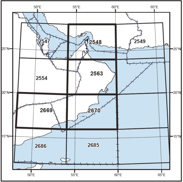
World Aeronautical Chart-ICAO
(WAC) |
1:1 000 000 |
WORLD AERONAUTICAL CHART |
2548-2563-2669-2670 |
70 OMR |
5 OCT 23 |
| TITLE OF SERIES | SCALE | CHART NAME AND/OR NUMBER | PRICE PER SHEET RO. | DATE | |
|---|---|---|---|---|---|
|
World Aeronautical Chart-ICAO
(WAC) |
1:1 000 000 |
WORLD AERONAUTICAL CHART |
2548-2563-2669-2670 |
70 OMR |
5 OCT 23 |